 |
 |
 |
 |
 |
 |
|
|||||||
|
|||||||
| GORGONA | |||||||
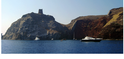
The northern, the smallest and the greenest island over the entire Tuscan archipelago. It is 17 Miles far from Leghorn; it has an irregularly quadrilateral shape, with a maximum length of 2.15 km, a maximum wide 1,5 km and 2,23 km² of total surface. Totally mountainous (maximum high, Punta Gorgona m 255), its western side is steep and almost sheer above the sea, in its east side instead declines with small hills covered by pine (Aleppo’s pine) and holm oak forest, Mediterranean undergrowth and cultivated terracements. The entrance of the small marina is overlooked from the New Tower (Torre Nuova) of Medicean age. Every Tuesday the Natural Park Cooperative Gorgona organizes guided naturalistic excursions (tel.+39 0586/884522), with departures from Leghorn. The visit it is allowed only with previous booking because the island is a Penitentiary Institute. |
|||||||
| CAPRAIA | |||||||
Capraria the Romans, 35 Miles far from Leghorn and 53 Miles from Piombino’s promontory. Capraia is an entirely volcanic island of elliptic shape, about 8 km long and 4 km wide and 19,26 km² as total surface. It counts 298 inhabitants. The island is montainous, is splited from north till 1 km to the sea south part by a chain of rocky mountains 400 m high, ending up to the top of Castello Mountain m 447 high. In the eastern side it presents little valleys furrowed by torrents flows down slowly towards the sea: the biggest one it is 3 km long and flows in Capraia’s marina. The Island is geologically costituited by powerful andesite out flows, and sometimes tufi and brecce, only at the Zenobito Point (south point) there are basaltic rocks due to more recent eruptions. All over in the rocky coast there are creeks and caves of rough beauty with pinnacles shaped by the sea water erosion. In the Island there are no streets but it offers many inland tracks, of different length: to the Ex Penitentiary Institute, today a cheese factory, to the lake or to some harbour and bays of the south side. The vegetation, extremely rich and with very rare endemic spices, is essentially costituited by Mediterranean undergrowth (sea cisto, mirtle, lentisco, rosmarin), in some areas there are oleanders and arboreal euforbia. |
 |
||||||
Before the animal populating was characterized by wild goats and monks seals (today extinct). The only centre of the Island is Capraia town, reachble from the port going up to Saint George Fort erected at the beginning of the XV° century. From Piazzale della Bellavista (100 m, about 15 minutes walking) from wich is possibile to admire the fabulous scenary of Elba Island. |
|||||||
| ELBA | |||||||
Tuscany, Leghorn’s province. In the soil there are tormaline, berilli, granati, magnetite, ologisto and limonite from wich the iron it is extract since 3000 years. The vegetation is vary: cactus, corbezzolo, chestnut threes, olive three, aleatico and moscato’s vineyard. Woodcocks, quails and thrushes come here on their passes. |
 |
||||||
Portoferraio. Since the ancient past is the main centre of Elba island. It counts 11042 inhabitants. It is surrounded by the IV° century bastions and gardens, used in the past to protect the city from the Arabic excursion. It is placed on the promontory which it closes upon the sunny biggest harbour of the Island. It is short the walk till Napoleon’s House, where he was exiled, he landed in Elba May 3rd 1814 till February 26th 1815, day of his departure. Marciana. Village on the high upon the slopes of the Monte Capanne and it counts 2244 inhabitants. It is an holiday resort place, surrounded by chestnut three forest which cover the northern slopes of the mountain; the castle’s ruins overlook the village and the wine yard terraces, the Mediterranean undergrowth and the valleys flowing down towards the sea. |
 |
||||||
Marciana Marina. It is a seaside resort village, 6,5 km north-east of Marciana, with small turistic marina. The village is on the northern coast, disposed in half circle all along the beach at the mouth of a big valley; at the beginning of the quay there is a tower of the XII century. |
|||||||
Porto Azzurro. The Spanish built Portolongone Fort in 1603, (today a Penitentiary Institute) located on the top of the promontory which overlooks the small town, the all harbour and the marina. |
|||||||
| PIANOSA | |||||||
Called from the Romans “La Planasia”, the origin of the name comes form the conformation levelled ground (m 27 is the maximum high). Pianosa is the closest island to Elba’s coasts (7miles). It has a sort of triangular shape, km 5,8 long, 4,6 Km wide and 10,25 km² as total surface. The island is a penitentiary institute, not accessible, since 1858. From a geological point of view is made mostly by calcareous shells rested on a marl substrate. On the east coast, in San Giovanni's Bay, just a little bit northern than Pianosa marina, there are the ruins of an ancient and luxury roman villa, where Agrippa Postumo lived (12 b.C. – 14 a.C.). |
|||||||
| MONTECRISTO | |||||||
Perhaps is the ancient Artemisia, or Oglasa, of the Romans, it rises 20 Mg south of Elba Island and 32,5 Mg west of Argentario’s Promontory; km² 10,39 of totals surface. Montecristo is constituted by a unique mass of granite culminating in 3 peaks (Fortezza’ s Mountain 645 meters, is the maximum high). The coast runs for 16 km, every where is steep and very irregular, with many creeks. The biggest one is in the south coast, Corfù Bay, a sort of big inaccessible gulf. The Island appears wild and inhospitable, cuts into big valleys and clefts, torments by the erosion which moulded the granite in bizarre shapes and “smoothing” the rocky slopes like big slides (called “liscioni”) or bumps. In the 1971 it has been declared earth’s natural reserve, in the 1977 European biogenetic reserve, in the 1979 sea biological protected area, at last in the 1989 included in the Tuscan Archipelago National Park. It is accessible only with previous booking of organised and guided visits, limited to 1000 visitors per year. For information: Follonica forest office tel. +39 0566/40019. Cala Maestra. Is the only landing place of the all island, in the middle of the western coast. On the small quay there is a royal Villa of the nineteenth- centuries, now abandoned. From there departs a mule-track which takes to the ancient Monastery of Ss.Salvatore and Mamiliano’s ruins. Founded by Benedictines Monks and abandoned in the 1553. Is told that the Monks took with them all their richness to the continent, originating the legend of the treasure buried by monks, becoming the famous subject of the popular novel “The count of Montecristo”, by Alessandro Dumas. Going toward north there are the ruins of the fort erected by Piombino’ s lords. Offshore the western coast comes out from the sea Africa cliff or Montecristo’s ant, a small rocky bank on which there is the lighthouse. |
|||||||
| GIGLIO | |||||||
Second biggest island of the Tuscan Arcipelago. Grosseto’ s province, it counts 1558 inhabitants and it has 21,21 km² as total surface. |
 |
||||||
Giglio Campese. Is in the north-west side and there is a big touristy beach. Giglio Porto. The marina is on the eastern coast and it is the best landing place; the village, all crowed round the marina, is lively in summer time. Giglio Castello. Ancient village, 6 km north west of Giglio Harbourgh, closed from a circle of middle age walls; the Fort has a fourteenth century door and overlooks the all scenery. |
|||||||
| GIANNUTRI | |||||||
The southest island of the Tuscan Archipelago, administrative included in Giglio Island ’s Municipal office, to which is far 16 km south-east. It has half moon shape, 2,6 km long and 2,62 km² as total surface. The island has 3 poggi: Capel Rosso m 88, Mario Mountain m 78 and Cannone Mountain m 68; connected by a crescent of low land, 29 m. Almost every where falls in a slope of reefs. Calcareous nature, the coast is almost every where rocky, with just two gravelly beaches. No far away in the north, on the rocky coast there is the big Domizi Enobarbi Villa’s ruins (it is possible to visit it just in part), erected around the I° century b.C. and then came in the imperial Heritage cause of Nerone’s wishes. There is a luxuriant Mediterranean undergrowth characterized by the holms oak where peregrine falcons (protected species by the communitarian instructions), woodpeckers and royal seagull nest. |
|||||||


