|
Get on/out board Leghorn
2 nights (the first/the last) in Capraia - 4 nights in the north of Corse (possible stops: Macinaggio, Cape Corse, La Giraglia, Barcaggio, Centuri, Saint Florant, Nonza, Calvi)
Get on/out board Corse (north, Bastia or south, Porto Vecchio)
6 nights between north of Corse (possible stops: Bastia, Macinaggio, Cape Corse, La Giraglia, Barcaggio, Centuri, Saint Florant, Nonza, Calvì) or in the south west (possible stops: Porto Vecchio, golfo di Santa Manza, Bocche di Bonifacio)
Images and info about beaches, cultural and naturalistic itineraries in Corse, north and south:
www.allerencorse.com
|
|
|
|
|
Corse is laped in the north west by Ligurian sea and in the east side by High Tirrenic sea. Is geographically more closed to Italy (40 Mg from Piombino) than to France (85 Mg from Mentone), from Sardegna is 6 Mg far and less than 15 Mg from Tuscan Archipelago (Capraia Island).
Usually concern this island there are sort of touristy definitions, from the one “shining land of colours and light” to that one of “Île de beauté”.
A third and more known definition is “mountain in the meddle of the sea”, this is the most meaningful because it shows the more interesting landscape and environmental side.
The island has a total surface of 8680km², 180km as maximum length per 80 km wide, with an average altitude of 500m. |
|
|
|
|
| MACINAGGIO |
|
In a crouched bay, 140 inhabitans, surrounded by beautiful beaches, famous turisty marina for the cruises towards and from Tuscan Archipelago.
It is an historical inclination: always it is been considered one of the most protected and safe of the entire island. From here in 1571 the Corse fleet left with Genoa's flags to take part to Lepanto's battle and where Pasquale Paoli landed in 1761, taking away the marina to Genoa's domain, to use it, in 1767, as base for the conquer of Capraia island. Around the touristy marina, made of three basins equipped to grant more than 500 boats, is disposed the inhabited which has developed form the ancient centre till the modern buildings with the expansion of the port.
From the extreme northern part of the country begin the track which it takes to the long Tamarone beach and then to Capandula's protected area. Capandula's protected area goes from Macinaggio till Centuri and it is crossed by the charming “Doganieri Path” which it passes in front of Finocchiarola islands.
The area touches green pasture land declining towards the sea and about hundreds metres in land towards the sweet-smelling undergrowth. Then it passes the long Tamarone beach, parades before Finocchiarola’ s islands till Santa Maria Bay, where the homonymous genovese tower, today just a vertical section ruin, reflects in turquoise coloured sea. |
|
| CAPE CORSE |
|
Cape Corse it is like a finger pointing Provenzal and Ligurian coasts; from open sea the view of this long and lengthened promontory looks like a cargo-ship full of mountains.
Some days from up there, when blows the south west wind, the overall view seems to have the domain of three seas: in the east Tirrenic sea and Tuscan Archipelago's “fleet”; in the north Genoa Gulf, where whales crosses by; in the west open horizon of western Mediterranean Sea, with its sudden changes of light and sky.
The Cape is tacked for all its boundary long, by a traced in nineteenth century, narrow and tortuous street: in the west goes till next the coast, on the other side instead is developed at high altitude, almost inlayed in the mountain overhanging upon the sea supporting the tortuous coastal’ s state and giving foreshortening of unforgettable charm at every single bend.
The pathway is defined by many towers of guard, memories of how these populations lived under constant threat of incursions.
Cape Corse green and shining, is a mountain and sea at the same time. |
|
| BARCAGGIO |
|
Cape Corse's extreme northern part. Small and remote marina in a nice sandy dunes bay dune, in the shadow of Agnello's tower. |
|
| GIRAGLIA |
|
In front of Barcaggio marina, just 1 Mg far from the coast, overlooked by a light house which with its 30 Mg of range it has been for long time one of the most powerful of western Mediterranean sea. It is Giraglia island made of green serpentinite.
This cliff gives the name to one of the classical sailing regatta of the Mediterranean sea: Ghiraglia Cup, takes place in June along the triangular route: Saint-Tropez – Giraglia cliff – Genoa. |
|
| CENTURI |
|
Commune made of many villages (230 inhabitants) which occupy the slopes declining towards the sea south of Capo Bianco, promontory to the extreme north-west of Cape Corse.
Centuri marina is perhaps one of the more enchanting of Cape Corse, in a small bay faced by a tiny island; probably already populated since VI century. Around 1760 Centuri became Pasquale Paoli's navyyard little fleet.
The typical pastel coloured houses, with roofs's tiles made in green serpentinite, are tight round the small marina, often crowed of fishing boats – lobster it is one of the specialization of the place – and pleasure boats. |
|
| SAINT FLORENT |
|
Crowed seaside resort (5m altitude, 1474 inhabitants) rises at the and of the homonymous gulf, tight in between Cape Corse’ s peninsula and rocky Agriates Desert, and goes for all the way towards the sea on a small calcareous promontory watched by the circular genovese Cittadella.
The ancient village is extent till the modern village which gravitates all around to an equipped and very crowed touristy marina, which can gives shelter to almost 800 boats. |
|
| NONZA |
|
Plunged in the green of fruit threes and vegetables, more than 100m high overhanging upon the sea. Nonza (152m altitude, 67 inhabitants). It is Cape's small jewel, and surely one of the most charming place of the entire Corse.
Along the narrow little streets are faced old houses with roofs made of grey stone slabs, the from are painted in delicate pink, ochre and yellow colours embellished with inlayed and decorated doors.
The promontory is surrounded by the village, climbed high in a defensive position, where the quadrilateral tower of green serpentinite rises. It was built in 1760 upon a previous meddle age castle's ruins, destroyed it by genoans; from here the view of the scenery is spectacular, from the underneath “black beach” till Saint Florent's gulf. |
|
| CALVI |
|
Placed on the homonymous gulf (81m altitude, 5177 inhabitants). It is an important touristic village renowned for the ugly beach, for the equipped marina and for the modern villages resort.
The town is located in two side: on top the old Cittadella, high up on a granite promontory, historical and architectonic evidence of Genovese age; at the bottom the Marina where there is intense commercial and touristic activity (market, shops, caffè and restaurants). The low town is connected to the walls of the high town by a path way.
The Cittadella encloses Palazzo dei Governatori of XIII centuries, Saint-Jean-Baptiste Church and St-Antoine Prayer House.
Wonderful foreshortening on Revellata Point's reefs, not far from Clavi there are ideal places to admire the sea bottom diving or snorkelling. |
|
| BASTIA |
|
Of the all Corse, Bastia is the “door on the Tirrenic Sea”, then on Italy. The biggest majority of turistic flow coming from the Peninsula lands here. The impressive front of St-Jean-Baptiste Church, Cittadella's mole and the mountain’ s frame around which goes up by the lee of the city, are from the boat, the first shot of the travel into the so-called Île de Beautè.
Bastia has the taste and the colour of Mediterranean cities and the ideal is to discover it without many plans, just been curious walking around the little, narrow and tortuous in land streets between the colourful embrace of the Port.
Bastia is the main, commercial and industrial port and city of the all Island (71m altitude and 37.884 inhabitants). Located at the beginning of Cape Corse.
The historical city has a typical liguarian style, is made of two separate quarters all around the Vieux Port: in the north side there is the low city, called Old-Land, place of the primitive settlement grown on the ancient fishermen village; in the south there is the High city, called New Land and where the Cittadella Fort is placed. |
|
| PORTO VECCHIO |
|
Porto Vecchio, “sails's Republic”, is the third city of Corse. In the back of the city there is a wonderful hill of 8.000 hectares cork-oak forest, the most important of the all Corse. The hill became soon mountain and the Ospedale forest of larch pine threes (wood used to build boats). This is one of door to access to the High Rocca, micro-region dense of history and forests.
The city is overlooked by a sort of Dolomitic symbol: the seven tops of Bavella’ s aiguilles, like an organ pointed towards sky of Corse, able to change colours depending on the sun light, hundreds of toning down from pink to purple.
The way which is very close to the one of Bavella Hill, seems cut into the rock, and winds between cluster pine threes and granites rocks. Solenzara coast ends up on Nacres coast, rocks and reefs, limpid water and pearly shells, from which the coast takes the name.
Porto Vecchio is an ancient city, port of genoan's origins (70m altitude and 10.326 inhabitants), after Bastia, is the main centre of the east coast.
The gulf is closed between San Cipriano Point in the north and Chiappa Point in the south and it gets sandy cause Osa and Stabiacco rivers's deposits flow into the sea.
The beaches due their rosy colour to the smashed outcrop granites rocks; The sea bottom is not deep and all the beaches are equipped for seaside resorts and water activities, except those around Piccovaggia peninsula.
The old town, defends by the geanoan forts of XVI century, overlooks the sea upon a pink porphyry hill, 70m high. |
|
| SANTA MANZA GULF |
|
Santa Manza Gulf's beaches are the more beautiful of the entire Corse, connected each other and close together between Bonifacio and Porto Vecchio.
It is placed 6km east of Bonifacio, it is a well protected gulf which offers moorings in Gurgazu's small marina.
The main beaches are the homonymous and Maora one but there many others little bays around. |
|
| BOCCHE DI BONIFACIO (MOUTHS) |
|
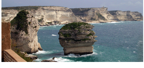
Seen from the sea, Bonifacio seems surrealistic suspended on a fragile calcareous boulder, the houses are overhanging on the cliffs looking like are flying down into the flutti underneath.
Bonifacio has been compared to a “rocky boat” for its position on a flat calcareous extremely white tableland (about sixty meters on the sea level) extended parallel to the coast as natural defends of the port.
Ancient genoan fortress (64m altitude, 2658 inhabitants) is the southern city of the Island which faces on the extraordinary white cliffs of the windy Bonifacio's Mouths, 6 miles of sea which separate Corse from Sardinia.
This extreme south part of the Corse precipitates like a mountain into the sea: with cliffs overhanging, little bays made of granite smashed in sand and caves in between land and sea.
Around Bonifacio, going up the coast towards Porto Vecchio there are plenty of spectacular places where you can feel into a sort of “communion” with the sea: diving into the sea bottoms crowed like aquariums, or ploughing the waves, unfurling the sails in the wind or simply staying on a beach, on a rock or on a boat in the sea.
Today Bonifacio is a city almost for tourists especially in summertime, period in which the sunrise and sunset hours can offers extraordinary show of colours and surprising special natural effects.
The Marina. High calcareous cliffs protected by the winds, the Turistic and Fishing Port, layed down on the fiord's bottom animated by hotels, restaurants, caffè, shops which have transformed the all place in the most famous trendy town of the Island.
On the sea coast there is the aquarium: settled in a calcareous cave dug in the rock, gives hospitality to exemplary sea fauna, typical of Corse, lodged in thirteen fish tank to recreate the different natural habitats.
Passing in front of Arenella Chain's calanques and then passed over Madonetta Point, into Sdragonato cave, where the profiles of the entrance remind Corse's shape up side down; the light filtering combines with the red algae on the rocks in the bottom which produces an effect of strong fascination and the sea assumes a purple colour.
The old town. Is the high city made of the ancient quarter and by the Cittadella. It is closed in a circuit of heavy bastions walls.
This part of the town occupies the western side of the promontory; the bastions, which surround it, and the big tower are what remains of the fortifications built by genoans through the XIII and XIV centuries to defends theme selves from the marauders.
|
|